As the fitness technology space is always evolving, precision serves as the very foundation for the ultimate advancements. For cyclists (whether they are recreational, BMX, or professional mountain bikers), precision is the key to turning a casual ride into a progressive path toward an athlete's best performance.
To be at the forefront of this movement, a product called Moro Tracker was created by BMAC Infotech in 2026. It is the premiere GPS-based solution for cyclists and uses the advanced sensors built into smartphones to collect and provide users elite-level performance metrics without the need for additional expenses associated with standalone bike computers. This guide provides an overview of how Moro Tracker provides cyclists with accurate tracking of distance, speed, and routes, along with how it is considered one of the most important technological tools for cyclists worldwide.
1. What Makes This New Technology So Accurate?
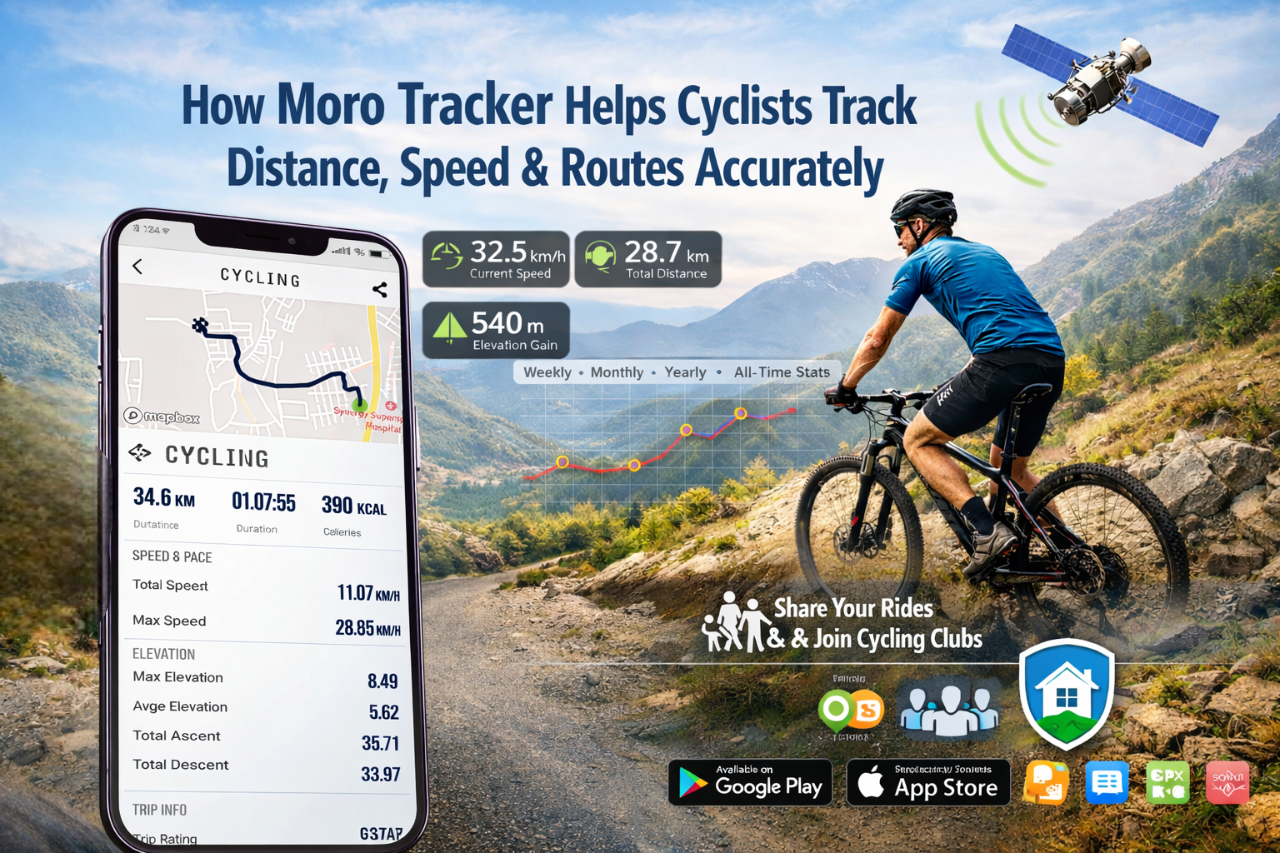
There Is No Such Thing As Too Much Accuracy. GPS technology is one of the distinct features of Moro Tracker. Moro Tracker's unique integration of GPS and GLONASS with high-resolution logging allows users to track their movements in real-time by connecting to multiple GPS satellites while providing a high level of accuracy with every single movement.
Surface Mapping Rent Realistically
Whereas most tracking systems use techniques such as smoothing to approximate your path, Moro Tracker has the ability to accurately map your path using both horizontal and vertical measurements of distance with minimal error. Whether you ride on an urban or mountainous course, the surface map of your ride can provide you with an accurate visual representation of where you have been and how far you have gone.
Elevation and Distance Calculators
Distance traveled is not only measured by horizontal movement; the distance traveled in vertical movement is also equally important to the cyclist. Using barometric and GPS data, Moro Tracker can calculate the following:
- Total Mileage: The total accumulated mileage you have traveled, calculated by continuous updating of the GPS coordinates you have traveled.
- Elevation Gain: The amount of elevation you have climbed based on both GPS and barometric readings.
2. Live Speed and Performance
The cadence of your workout (pace) is an important feature for performing productive endurance training or doing interval workouts. The functionality of the Moro Tracker application provides a "live cockpit" on both Android and iPhone devices.
Speed Tracking
The application calculates speed by using the elapsed time between two GPS points while moving through space. Speed information is displayed in the following ways:
- Current Speed: Displays your current speed so you can adjust your effort immediately.
- Average Speed: Another important indicator for time trial and long-distance riders to measure the overall efficiency of their riding.
- Maximum Speed: A real-time recording of your maximum speed when going downhill or sprinting to show you where you exert the most power.
Auto Pause/Restart
One of the most significant sources of faulty speed data is idle time, which occurs when you are stuck at traffic lights or stopping for water. The Moro Tracker application has an Auto Pause feature that detects when your speed drops below a predetermined threshold and automatically pauses to ensure that the average speed recorded is based upon the time in which you were actively riding, as opposed to the entire amount of time spent waiting for a green light.
3. Advanced Analytics: Analytical Powers Derived from the Data Collected
The value of the data collected is only as good as the ability of someone to take the information from raw form to an actionable state. The ability of Moro Tracker to take unrefined coordinates and speed and convert these to professional-level analytics is what sets them apart from other tracker companies.
Four Types of Tracking
Moro Tracker's tracking capabilities are broken into four distinct time periods to help a person view the entire picture of their training:
- Weekly: Allows for monitoring of short-term training loads.
- Monthly: Allows for tracking of both consistency and the building of endurance.
- Yearly: Provides a view of long-term health trends and seasonal variations.
- All-Time: Maintains comprehensive records of an individual's complete history as it pertains to cycling.
Caloric and Energy Output Comparison
Moro Tracker's estimation of calories burned is based on a rider's distance ridden, speed, and elevation gain, allowing a cyclist to properly match their post-ride nutrition with the actual energy output of their ride.
4. Safety and Social Integration
The ability to track your activity goes far beyond numbers. Tracking has evolved into a community activity that allows cyclists to share information with friends and family while working together to create a safer environment for each other on the road.
Privacy Zones
One of the most important issues for a cyclist is the need to avoid publicizing their home and work addresses (start and end points). The new feature from Moro Tracker allows you to create "Hidden Zones" or Privacy Zones. This means that within this area, your GPS coordinates can be searchable for your own personal stats but will not be posted on a public map feature, keeping your home and work address private.
Clubs and Community Events
The club management section of the app is very strong and allows for easy club management. The app allows you to:
- Join your local cycling clubs and participate in upcoming community cycling events.
- Get real-time notifications of all group rides.
- Compare your performance with other local cyclists and view
- A leaderboard of those cyclists to promote healthy competition among cyclists.
5. Technical Versatility for All Riders
Moro Tracker is designed to be inclusive of all cycling disciplines. Its multi-bike support ensures that your stats for different terrains don't get mixed up.
| Bike Type | Primary Metric Focus | App Benefit |
| Road Bike | Average Speed & Cadence | Aerodynamic efficiency tracking. |
| Mountain Bike (MTB) | Elevation & Technical Routes | Precise tracking in dense forest cover. |
| BMX / Indoor | Duration & Intensity | Tracks effort even on shorter, high-intensity bursts. |
| E-Bikes | Range & Route Planning | Optimized for longer journeys with battery-conscious GPS. |
6. Effortless Management of Data
The versatility of this application is not just limited to the ride. As well as being compatible with many of the other GIS and fitness applications around, it can export data in KML, GPX, and CSV formats.
- Being able to export rides to Strava, Garmin Connect, or any other platform that utilizes GPX is what it does best.
- KML/GeoJSON routes can be printed in 3 dimensions using Google Earth or used in conjunction with many professional GIS mapping applications.
- Offline operations: This application only uses the device’s internal GPS, which means it will record your data even when outside cellular coverage, allowing users to take advantage of the features when they are on some of the most secluded trail systems.
Conclusion: Why Moro Tracker?
Moro Tracker has focused on what the majority of 'smart' technologies have made overly complicated: the fundamental principles behind accuracy, reliability, and ease of use. It has eliminated the need for storing multiple pieces of bulky hardware (i.e., bike computers) and now allows you to use your smartphone device as a fully functional bike computer to be placed in your pocket or installed on your handlebars; not only will it provide you with the distance, speed, and routes of your rides, but it also empowers you to exceed those rides in the future.
 Sign up with google